Whether you need a certified plot plan for a home addition, a survey for a 100-acre subdivision, or an ALTA title survey for commercial financing, Merrill’s in-house land surveying division has the expertise to do the job right.

Dedicated Survey Division Support
At Merrill, licensed professional land surveyors work as integral members of our project teams. Our dedicated land survey division allows us to meet critical client deadlines by controlling the survey schedule.
Merrill’s in-house survey group also allows us to support multiple projects at every phase of development, from topographic and existing condition surveys to construction layout and as-builts.
Precise Data Capture and Processing
Merrill’s professional land survey group uses the latest in precision survey equipment, including dual station GPS systems and robotic and semi-robotic full stations. Our highly skilled technicians use the latest survey software and AutoCAD Civil 3D to support projects requiring BIM data and designs.
Typical Land Surveying Services
- GPS surveys
- FEMA flood elevation certification
- Chapter 91 dock permit surveys
- Aerial and site photography
- Construction layout
“We have known Merrill for more than thirty years. Such professional association has included large subdivisions and single lot projects. Regardless of the size of the job, Merrill Corporation has consistently delivered prompt and economic engineering and surveying services to our clients. We recommend them highly.”
Walter B. Sullivam, Esq.
Sullivan & Sullivan, P.C.
Resources

What’s Missing from Your Plans? (Hint: It’s a Licensed Surveyor.)
A zoning board stamp isn’t enough—plans need a certified surveyor’s seal to avoid costly, preventable setbacks.
Featured Projects
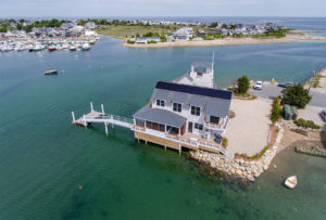
This project involved the razing of 3 pre-existing non-conforming structures and the reconstruction of one new single-family dwelling…
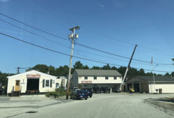
This project included the demolition of the existing metal building to the rear of the property and the…
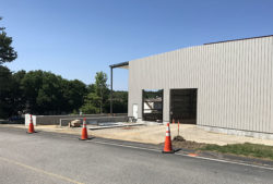
This project included the construction of a 14,316± square foot warehouse building located at #20 Lone Street with…
